An Emerald Embrace
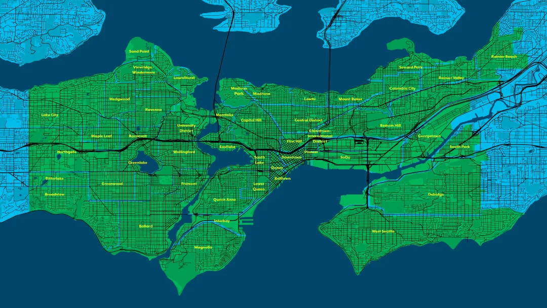
There is a lot of truth in calling Seattle “The Emerald City.” The lush green vegetation persists throughout the year with tall douglas fir and western hemlock dominating the landscape. In spring and summer, bouquets of flowering bushes & trees line the streets and run along homes. And the residents of Seattle, especially myself, deeply appreciate the spring colors as they appear, particularly the cherry blossom trees which show the early signs of spring after the long winter.
The greenery of Seattle mirrors the surrounding forests. As a city set between two mountain ranges and two major bodies of water, Seattleites have no choice but to witness the natural beauty around them. As I visit different neighborhoods in Seattle, I find it hard not to notice how intentional the road placement is as I look west and see the Olympic Mountains rising over the Puget Sound, East to Lake Washington and the Cascade Mountains, or south to see the picturesque Mount Rainier.
Seattle is a beautiful, green city, it was planned to be so from its founding. When looking at the numbers, Seattle is the 10th greenest city in North America, with 118.3 m2 of green space according to the Husqvarna Group’s HUGSI online resources. Today, Seattle holds a Tree Equity Score of 93, the 3rd highest of the greenest cities in the United States according to HUGSI. This Tree Equity Score “measures how well the benefits of trees are reaching communities living on low-incomes, communities of color and others disproportionately impacted by extreme heat and other environmental hazards.” (Tree Equity Score) However, access to Seattle parks has not always been equitable. In response to past inequities, Seattle’s parks and trails systems offer opportunities to connect with nature across the city and actively work to improve access to all those who live in Seattle.
Coast Salish Land
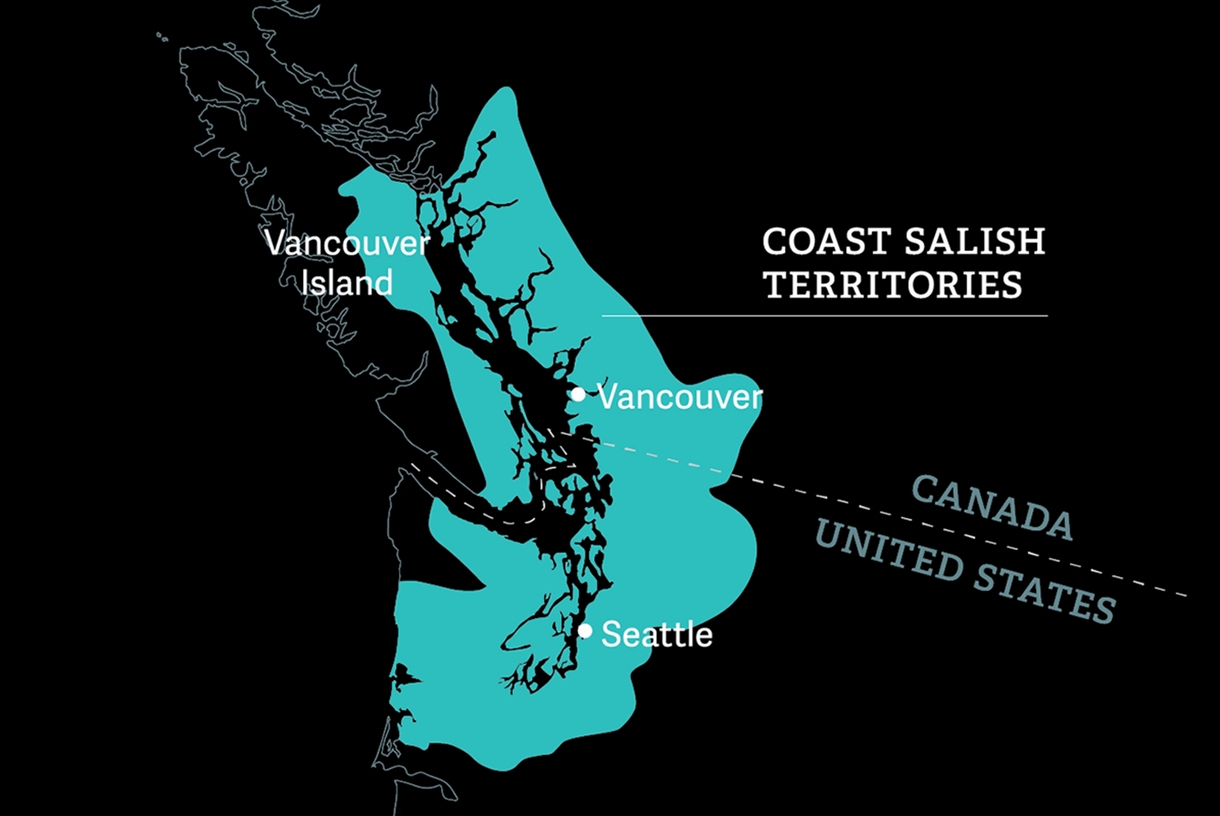
The rich history of the City of Seattle starts with the land it sits upon. Adjacent to the southern portion of the Salish Sea, nestled between fresh and saltwater, the Duwamish people lived and thrived for millennia. These Lushootseed-speaking people live off the bounty of sea life, berries, and greens the region provides, notably the salmon iconic to Seattle. The story of the Coast Salish people is not unlike many other tribes in the Americas who were forced off their land. However, the Coast Salish people continue to live throughout the state of Washington, their stories and histories continuing to influence food, art, and culture across the Pacific Northwest today.
The Olmsted Legacy
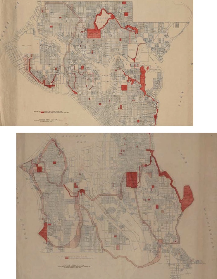
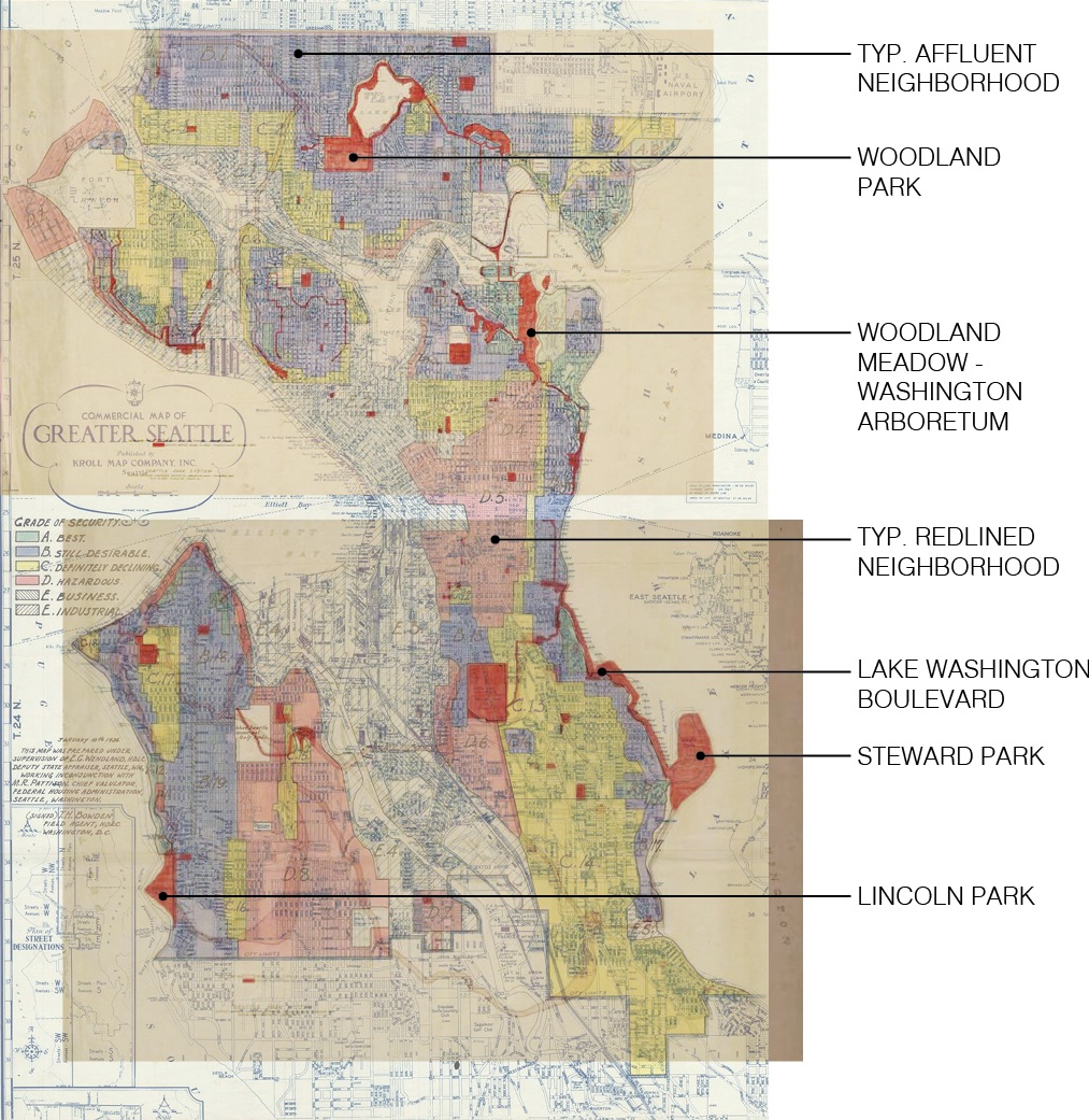
Seattle was founded in 1851 and grew quickly as a major western North American port city and a gateway to the Yukon Gold Rush. In 1903, the City proposed planning a park system in response to the exposition. The City commissioned the Olmsted brothers to design such a park system. This plan envisioned an overarching Parks & Boulevards Plan for the City. The park features major park nodes with green fingers connecting the various parks. Within the parks, a few of the most notable are Woodland Park, Woodland Meadow – Washington Arboretum, Steward Park, Hiawatha Playfield, and Lincoln Park.
This network of parks and boulevards were to become the backbone for Seattle’s parks system. With major connections like the Lake Washington Boulevard, the plan encouraged citizens to move freely between the parks while connecting with the City.
Redlining
However, not long after the Olmsted Parks were planned to connect all residents to parks, the use of redlining created vast segregation throughout Seattle. Between the early 1900s to the 1970s, redlining was a banking policy where loans were restricted for those who lived in areas where housing costs were low, or areas in red in Figure 4, and were disproportionately Black, Brown, and Coast Salish communities. The legacy of redlining policies continue to have resounding effects on who has access to housing, and to parks in the City. An overlaid view of Figures 3 & 4, shown as Figure 5, identifies just how closely Seattle’s redlining followed the Olmsted park system.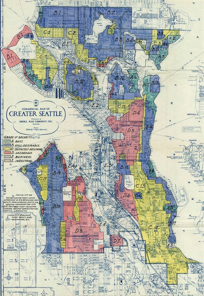
The Olmsted Park Plan & Redlining Correlation
New Parks
In response to Seattle’s past, the City of Seattle’s Parks & Recreation Department aims to develop parks which address inequalities while providing necessary public amenities to its residents. These new parks take a variety of shapes, from ecological restoration to enhanced trails. Through its efforts, Seattle has been ranked as one of the best cities for parks in the United States, and the variety of parks the City has to offer proves why.
Union Bay Natural Area
With Seattle’s industrial past as a logging and shipping city, ecologically critical spaces such as wetlands became polluted by waste. This was the story of the Union Bay Natural Area before intentional restoration choices revitalized the wetlands. Now, it is an ideal location to bird watch and connect with a reconstructed natural space.
Small parks & P-patches
One unique feature of Seattle’s park system is the speckling of small parks around neighborhoods. These spaces provide a localized refuge in many of Seattle’s neighborhoods
Seattle also boasts 90 community gardens around the City called the P-Patches. These gardens offer people opportunities to meet others who value self-produced food and reinforce a localized metabolic system.
Trails & Green Infrastructure
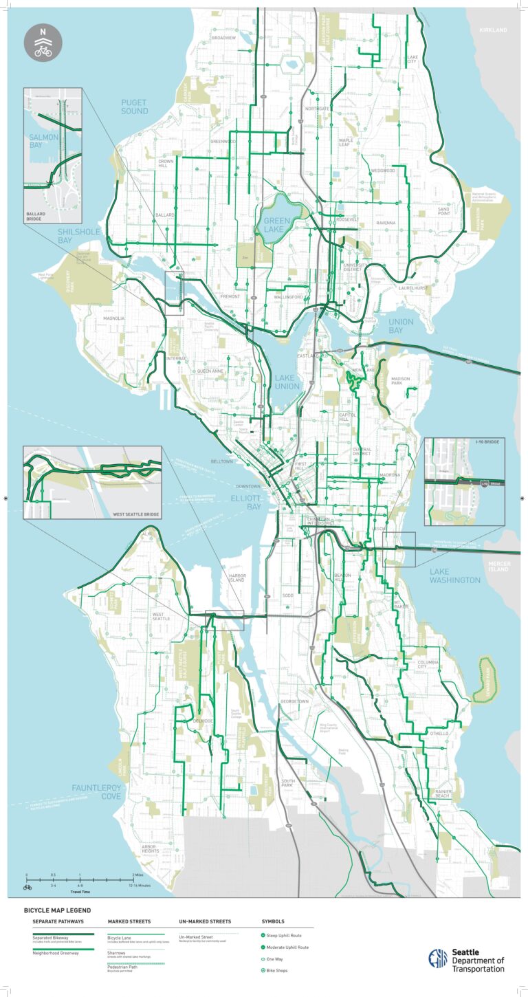
Even with Seattle’s ever expanding bike lanes along roadways, many pedestrians and cyclists utilize the trails which line the City. With both the trails and bike lanes, Seattle has incorporated green infrastructure in the form of bioswales, rain gardens, and permeable surfaces. The trails and green infrastructure developing in Seattle reduces stormwater pollution from runoff while continuing to increase the urban nature of Seattle.
Green Projects around the (Puget) Sound
The park system around Seattle provides its communities with valuable open spaces. But Seattle is but one of a number of growing cities in the Puget Sound region. Two notably growing cities in this region are Everett to the north and Bellevue to the east. These cities each are bringing innovative new plans for parks and open spaces within their borders.
Snohomish County, where Everett is located, holds valuable farmland in Washington State. To recognize the importance of food production in the county and between producer & consumer, the Snohomish County Food and Farming Center has opened in Everett’s McCollum Park. With a space to connect, farmers can sell directly to kitchens, individuals, or even put on cooking demonstrations themselves.
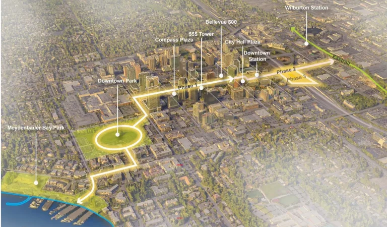
Across Lake Washington to the east of Seattle, the city of Bellevue rises out of the surrounding trees with new highrises and infrastructure. With this development, Bellevue’s Community Development Department has designed a series of projects to enhance multimodal mobility between parks in the city. Named The Grand Connection, this series of projects will not only connect green spaces, but improve local business and create a connection to place for those moving along these trails and walkways.
Green Public Life
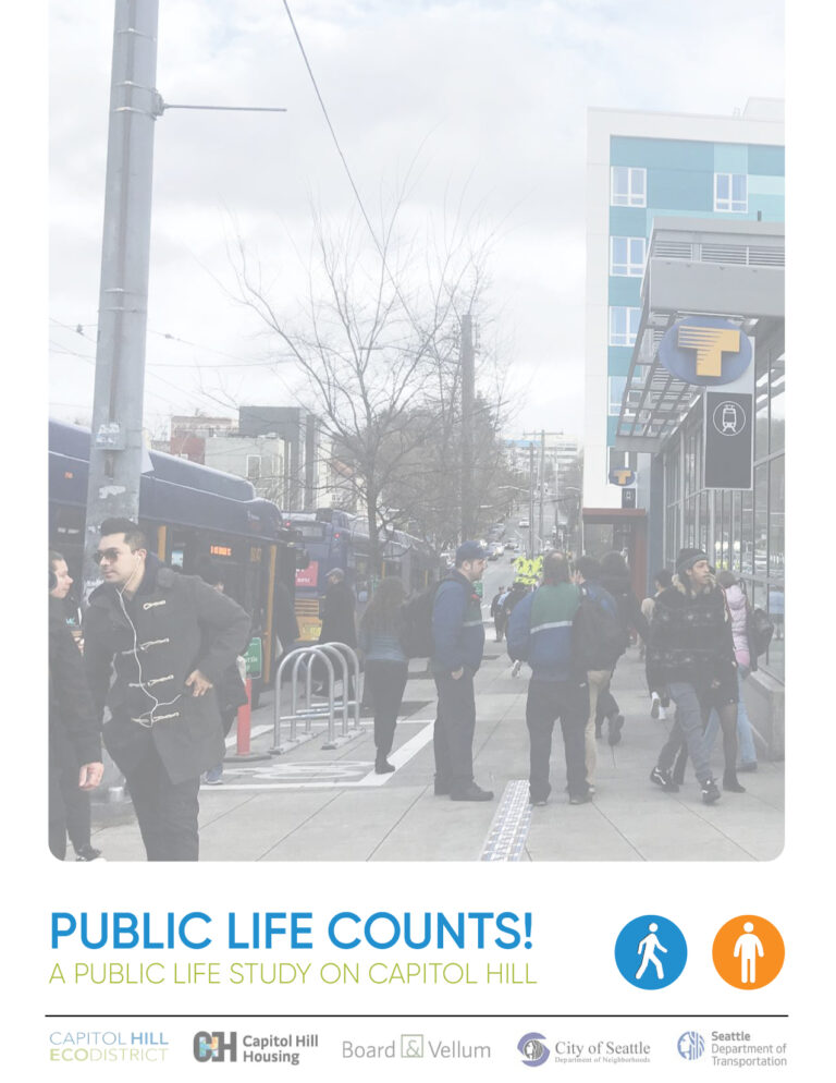
Connecting people to parks & open spaces is essential to a vibrant public realm. In Seattle, I have helped move towards this goal by providing data-driven public realm design recommendations based on Gehl-method observational counts. The Public Life Counts! study allowed me to work with a team of volunteers to count people moving through a space, people staying in a space, what people do when stationary, and what the environment conditions were during the study period.
Our design recommendations suggest a variety of infrastructure improvements at various locations: a permeable plaza entrance to a park, tabletop walkways for pedestrian safety, enhanced green edges, seating near businesses, and lean bars at bus stops. This last improvement, lean bars, were adopted by the Seattle Department of Transportation. This public realm element allows for a feeling of rest without fully sitting down in public, which was noted to make people feel unsafe at night.
Conclusion: A Green Future for Seattle
Working with communities to build up a great new generation of parks is critical to the health, well-being, and holistic sustainability of Seattle neighborhoods. For planners, landscape architects, city officials, and developers, finding ways to increase public realm amenities through green infrastructure & park enhancements will lead people towards positive connections with space and with each other. With historical inequities, Seattle’s planners must also continue to focus towards an equitable distribution of parks while working with community leaders to reduce the risk of green gentrification. Designing a green city not only benefits the people of the community, it also reduces environmental pollutants which damage ecosystems.
The people of the land situated between mountain ranges and fresh & salt water have long been connected to the natural environment. But what’s green in Seattle isn’t just what’s around the city, it’s what’s within the city and the value residents hold for these open spaces.
